
Huddersfield Southern Corridors
The Huddersfield Southern Corridors project was completed in April 2026, transforming one of the town's busiest gateway into a smoother, greener and more welcoming for everyone.
The southern corridor approaches into Huddersfield town centre and experienced traffic congestion, with slow journey times and facilities not suitable for walking, wheeling and cycling. The area has been significantly improved with new link roads, a dedicated bus lane, junction designs and upgraded walking and cycling routes offering more choice for people to travel.
We've also enhanced the public areas along the corridor with new landscaping, greener surroundings and high-quality footpaths, creating an inviting space and environment for residents, businesses and visitors.
These improvements support easier travel into the town centre and strengthen connections across the wider transport network in Kirklees and is a major step in making Kirklees a cleaner, more accessible and better-connected place to live, work and visit.
Huddersfield Southern Corridors is funded by West Yorkshire Combined Authority's Transforming Cities Fund .
Lockwood Bar
The left turn from Lockwood Road into Bridge Street and the right turn from Bridge Street into Lockwood Road is limited to buses only. A new link road with traffic signals at Crowther Street provides a two-way traffic link between Albert Street and Lockwood Road. Pedestrian and cycle crossings have been installed as well as cycle lanes and shared footways. The carriageway has been resurfaced, as well as improved footways, new kerbing and improvements to outside community spaces.
Plans
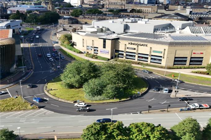
Plans have been developed to improve key routes into Huddersfield town centre from the south.
The construction of Folly Hall and improvements on Queen Street South were completed in 2023. Works included improvements at the junction to Colne Road and St. Thomas Road, to help reduce peak time traffic and improve journey times. The right turn out of Colne Road was removed, and an alternative route created along Queen Street South.
The series of works included resurfacing the carriageways, replacing kerbing, improving the central reservation, and upgrading traffic signals and pedestrian crossings.
Work was carried out on both sides of the carriageway from Albert Street to Shorehead Roundabout. This phase was completed in 2024.
A further scheme on Queensgate to make additional improvements to cycling and walking infrastructure is currently paused.
Plans have been developed to reduce the volume of traffic through the community area. Lockwood Road and Bridge Street will be limited to bus and cycles, which will have a positive impact on traffic flow for all vehicles. A new link road between Lockwood Road and Albert Street will be created, and the pelican crossing will be relocated.
The carriageway and footway will be resurfaced, and there will be new pedestrian and cycle infrastructure. Improvements to the local area and landscaping will create a place for the community to enjoy. This will bring overall improvements to the area by promoting active travel by cycling, walking and use of public transport.
Benefits
More accessible and better transport links, however you choose to travel, making it easier to access more education, employment and leisure opportunities.
Redesigned junctions and a dedicated bus lane improve the flow of traffic and journey times for all.
New cycle lanes and safer pedestrian crossings, make walking, wheeling and cycling a safer, more accessible choice for more people.
Improving junction design, pedestrian crossing and separate cycle lanes make it safer for users.
Tactile paving, pedestrian crossings and easier access to public transport.
New green landscaping, wider footways and preserving the local history have helped to create a more attractive, safer place where the local community can enjoy, spend time and local businesses can continue to thrive.
Safer pedestrian and cyclist access, along with stronger links across our transport network enables more people to choose different modes of travel and rely less on private vehicles. This helps reduce traffic and support air quality.
